A new map will help walkers and other visitors to Hadrian’s Wall Country to identify the Roman forts as well as features like temples and civilian settlements that lie all around this fascinating route through history.
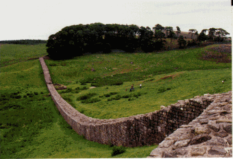 Over 10,000 people walk Hadrian’s Wall Path end to end every year but many of them miss much of the archaeological remains along Britain’s longest and greatest historic monument.
In addition to the well known forts like Chesters, Housesteads and Birdoswald, and Corbridge Roman Town, the map, which is published by English Heritage, shows the great earthworks and barriers that survive, along with the remains of roads, bridges, temporary camps, watchtowers, fortified gates, civilian settlements, bathhouses, temples and cemeteries.
Hadrian’s Wall is a Roman fortification which has stood along the northern frontier of Roman Britain since AD 122 and stretches 73 miles from the Solway Firth to the North Sea through stunning upland countryside, beautiful farmland and the vibrant cities of Carlisle and Newcastle. Hadrian’s Wall was more than just a wall; it was a whole military zone, designed to control movement across the frontier of Roman Britain.
The English Heritage map covers a distance of more than 100 miles showing the locations of all the known archaeology around the Wall, as well as the Roman defences along the Cumbrian coast down to Maryport. It distinguishes between those remains that are visible and those that have been levelled or built upon.
Walkers are also encouraged to take a respite trip to one of the four English Heritage managed sites along the wall where they can discover more about how the Romans lived and stock up on refreshments for their onward journey.
Humphrey Welfare, English Heritage’s Planning and Development Director for the North, said: “Just like major military sites today, the Wall was a complex system of defences and communications; extensive civilian settlements grew up alongside it, and the whole area was a hive of activity for three hundred years. This new map shows all of the archaeological sites along the frontier from the mouth of the Tyne to the Cumbrian coast. There is so much to explore and to discover; the map will enable visitors to see these landscapes through new eyes.”
The map will have enormous appeal for walkers and hikers, heritage professionals and enthusiasts but also for general visitors and tourists.
It is the only map to depict the archaeology of the Hadrian’s Wall corridor, taking into account all recent archaeological discoveries and revisions. It depicts the fruits of modern archaeological research: from field survey, geophysics, excavation, and the analysis of aerial photographs.
It is based on the archives contained in the National Monuments Record and County Historic Environments Records and the research of many individuals and organisations, and is on an Ordnance Survey Scale of 1:25,000, which is ideal for walkers.
The map costs £7.99 and is available from shops or by going to English Heritage’s online shop at: english-heritage.org.uk
Linda Tuttiett, from Hadrian’s Wall Heritage Limited, says: “This map is a great way for visitors to learn more about the amazing history of the Wall and the surrounding area. It is fantastic that people can walk the Wall while looking at the map and find out more about the wealth of archaeology from the time of the Roman Frontier here nearly two thousand years ago.”
The Hadrian’s Wall Path National Trail is one of the most popular trails in the country, with its 84-mile route attracting thousands of walkers to enjoy the unique experience of walking through rugged moorland, rolling fields and dynamic urban landscape, alongside such an important historical monument.
Visitors can use the AD122 Hadrian’s Wall Country Bus service to help plan their walk. It is a convenient and sustainable alternative to using the car and links the Trail with the towns and villages along the route. Single, return and value-for-money Rover tickets are available. For more information go to: hadrians-wall.org
For information about how to minimise the impact of your visit on the archaeology of the Hadrian’s Wall area, as well as a full list of walker friendly accommodation and information about Hadrian’s Wall Country and to plan your walking itinerary, visit: hadrians-wall.org and nationaltrail.co.uk/hadrianswall
For more information about the opening times, events and admission prices at English Heritage’s Roman sites, visit: english-heritage.org.uk
Source: Easier Travel [July 15, 2010]